
Hungary
A common saying was that it is easy to enter a Hungarian house, but difficult to leave, because the host tries to keep his guest as long as possible.
Along with hospitality, another typical trait of the Hungarians is their courtesy in social relations, and their love of music, as shown by their great musicians Brahms and Liszt, the traditional tzigane dances, and more recently the popularity of jazz. Music accompanies visitors also in the many restaurants and locals where the traditional, spicey food is served, along with the celebrated Tokai wine.
In short
Area: 93,030 km²
-- Population: abaut 10,000,000
-- Density: 109 per km²
-- Government: Parliamentary republic
-- Capital: Budapest
-- Language: Hungarian
-- Religion: about 51% Catholic, other minorities
-- Currency: Forint (HUF)
-- Telephone code: +36
-- International car plate:
-- Internet suffix:.hu
-- Member of: the UNO since 1955, the EU since 1 may 2004
-- Useful Links: Hungarian National Tourist Office | Phone book online (Hungarian white pages)
Administrative division
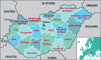
Hungary is divided into 19 counties called megyék, plus the capital city Budapest, independent of county government. The counties are subdivided into 167 subregions (kistérségek). Five towns have county's rights in addition to the county capitals: Érd (Pest county), Dunaújváros (Fejér county), Hódmezõvásárhely (Csongrád county), Nagykanizsa (Zala county), Sopron (Gyõr-Moson-Sopron county). The counties of Hungary, each with its capital, are:
Bács-Kiskun (Kecskemét),
Baranya (Pécs),
Békés (Békéscsaba),
Borsod-Abaúj-Zemplén (Miskolc),
Csongrád (Szeged),
Fejér (Székesfehérvár),
Gyõr-Moson-Sopron (Gyõr),
Hajdú-Bihar (Debrecen),
Heves (Eger),
Jász-Nagykun-Szolnok (Szolnok),
Komárom-Esztergom (Tatabánya),
Nógrád (Salgótarján),
Pest (Budapest),
Somogy (Kaposvár),
Szabolcs-Szatmár-Bereg (Nyíregyháza),
Tolna (Szekszárd),
Vas (Szombathely),
Veszprém (Veszprém),
Zala (Zalaegerszeg).
The Territory
Hungary occupies a wide plain, bordered by the Carpatian mountains to the north and crossed by the Danube from north to south, dividing the country into a western part, where the Balaton lake is situated, and an eastern part called Ålfold, where the Tibiscus river flows. Though the majority of the popolation live in the urban areas, the towns are mostly large villages, the only true large city being the capital. There is a good transport system with a navigable network of rivers spanning over 1300 km, and modern roads and railway connections.
History
Originally inhabited by German and Slav populations, Hungary was invaded in the 10th century AD by Majar peoples of Asian origin, who form today over 90% of the Hungarian population, and defended their unique identity for centuries. After many centuries of independence, the country was included in the Austrian-Hungarian Empire from 1699 to 1918. Then for long decades it was a communist republic under the influence of the Soviet Union with collective property of the land; in the 1970's and 80's the Hungarian government started to introduce a market economy, strengthening the private sector and finally in the 1990's there was a return to the private property of the land.
Cities and places of interest
The main city is Budapest, the capital, which with its metropolitan area reaches 2 million inhabitants. It is crossed by the Danube, which once separated two different towns, Buda an the right bank and Pest on the left bank of the river, which were united in 1872.
Other important towns are:
Debrecen, an agricultural and industrial centre,
Pècs, an art city and a mining town,
Seghedino, situated where the Maros joins the Tibisco river.
UNESCO World Heritage Sites

Cultural Sites:
Budapest, including the Banks of the Danube, the Buda Castle Quarter, the Andrássy Avenue and the Millennium Underground;
The ancient Hollóko village and surroundings;
Early Christian Necropolis of Pécs (Sopianæ);
Natural Sites: Hortobágy National Park — the Puszta; Caves of the Aggtelek and Slovenský kras (Slovak Karst), shared with Slovakia;
Mixed cultural / natural Sites: Millenary Benedictine Monastery of Pannonhalma and its Natural Environment; Cultural Landscape of Fertõ/Neusiedlersee, shared with Austria; Tokaj Wine Region Cultural Landscape
The Economy
Thanks to the fertility of the land, agriculture is an important resource, with the main crops being cereals, potatoes, vegetables, fruit, the vineyards in the North producing the celebrated "tokai" wine, the traditional red pepper from which paprika in extracted. Cattle and poultry are another remarkable sector, as well as race-horse breeding. Due to the scarcity of mineral resources, with the exception of bauxite, industry is developing in the more technologically advanced fields, as electronics and the automotive.